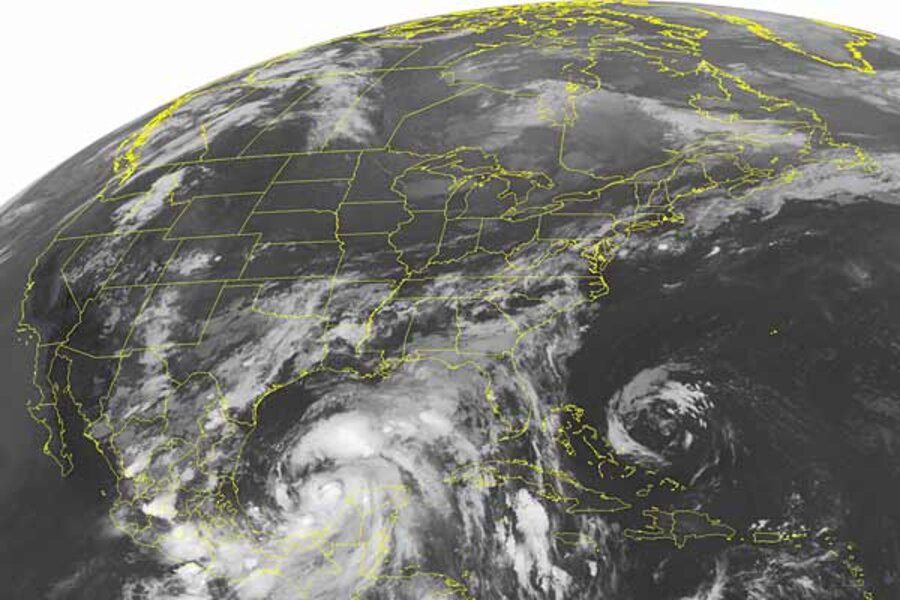
Hurricane Alex, first of 2010 season, heads for Texas, Mexico
Loading...
What began as a grumpy blotch of storm clouds over the Caribbean has become Hurricane Alex, the first of the 2010 Atlantic hurricane season.
The National Hurricane Center in Miami has posted hurricane warnings for a swath of the western Gulf coast from La Cruz, Mexico to near Texas's Baffin Bay. Tropical storm warnings extend farther along the Texas coast to Port O'Conner.
Forecasters say they anticipate a three- to five-foot storm surge north of where the eye makes landfall. The surge is expected to be capable of driving several miles inland before dissipating. Rainfall amounts are expected to range from six to 12 inches, with some isolated locations recording 20 inches of rain before the storm passes.
IN PICTURES: Huge hurricanes in the past two decades
The storm struck Belize June 24 as tropical storm Alex, then weakened as it passed over Mexico's Yucatan Peninsula and into the western Gulf of Mexico. Heavy rains fell on the Yucatan Peninsula, as well as on Guatemala and El Salvador.
In addition to people in the warning area, Alex has grabbed the attention of officials running efforts to control and clean up oil from the Deepwater Horizon blow-out, now beginning its 11th week. The storm itself does not directly threaten these efforts. But by some estimates, waves it generates could top 12 feet at the recovery site. Rough seas and high winds halted oil skimming efforts in the Gulf of Mexico Tuesday. Heavy seas could also break up patches of oil on the surface, and could drive oil higher onto beaches and deeper into wetlands unprotected by barrier islands.
"We have not seen any oil being pushed much further inland," said US Coast Guard Adm. Thad Allen, who heads the clean-up effort, during a briefing on Monday. "We have seen the oil change direction. It was generally heading east to the panhandle of Florida. Because of wave conditions and current we now see oil start entering Mississippi sound and areas around Chandelier and Breton Sound. We're very concerned about that. We're moving forces there as we speak."
The biggest concern comes from the prospect of a more-direct hit from a storm. Its surge "would, obviously, exacerbate the oil, move it further into marshes, and would cause problems for us," Admiral Allen said. "So we're going to face that potential throughout the hurricane season should we have any kind of heavy weather."
The Atlantic hurricane season's peak comes during the months of August, September, and October. Alex is the first June Atlantic hurricane since 1995, according to the National Hurricane Center.
Alex also marks the first Atlantic storm against which forecasters are giving county and city officials longer lead times for watches and warnings, notes Chris Landsea, the science and operations officer at the National Hurricane Center.
Until now, the National Hurricane Center issued a hurricane watch when a storm was 36 hours away and a warning when the storm was 24 hours out. Now watches are posted with 48 hours of lead time and warnings with 36 hours' lead time.
"Our definition of hurricane watches and warnings had not changed in three decades," he says. "But when you look at our predictions of where the hurricane is going to be, we've had a tremendous improvement in our skill."
Twenty years ago, a two-day track forecast had a 200-mile range of error, he says. Today, it's 100 miles. At the same time, the number of people living along vulnerable coastlines has mushroomed, a trend that keeps local emergency mangers awake at night thinking about evacuating people from popular but fragile barrier islands or other locations with limited evacuation routes.
In meetings with emergency managers, it became clear that watches and warnings under the old scheme were coming too late to be truly useful. to those officials who base their evacuation decisions on them, Dr. Landsea says.
"We didn't want them to become irrelevant," he says.
As the hurricane center gives its new approach its first application to Atlantic hurricanes, researchers are hoping to give forecasters even longer leads by allowing them to identify which "tropical waves" – seemingly haphazard assemblages of storms that can eventually evolve into tropical cyclones – are most likely to form tropical depressions, which can go on to form tropical storms and hurricanes.
The project is dubbed PREDICT – a month-and-a-half-long effort to take the measure of tropical waves as they form off the west coast of Africa.
The project, headed by Michael Montgomery, an atmospheric scientist at the US Naval Postgraduate School in Monterey, Calif., begins in mid August.
The difference between the tropical waves that fizzle and those that grow into more-serious storm systems seems to lay in what goes on in the heart of the wave. Waves that seem to form a circle-the-wagons closed circulation at their centers seem to be the storms that most often blossom into tropical depressions, the immediate precursor to tropical storms and hurricanes. That closed circulation appears to stave off storm-stiffling dry air that can come in from outside the system. That circulation also appears to concentrate the warm, moist tropical air on which tropical cyclones feed toward the heart of the storm system.
The challenge, Dr. Davis says, is to make sure that's the mechanism, then try to identify the drivers behind it. If researchers are successful, it may eventually be possible to begin providing tropical cyclone forecasts perhaps as far as seven days in advance.
The project also has a short-term payback, Landsea adds. The research aircraft flying through the tropical waves to gather measurements will give scientists and forecasters at the hurricane center a rare look at conditions inside these waves. The waves tend to form too far at sea for hurricane-hunter aircraft to reach on a routine basis.
IN PICTURES: Huge hurricanes in the past two decades
Related:


